Our Influences
We both grew up with deep connections to the land. Both of us grew up on farms, where woods, fields, streams, and animals were a part of our daily lives. We watched our parents care for the land in the best ways that they knew how. We also both watched our parents struggle financially to be able to earn their livelihoods from the land.
We also both grew up hearing hazy stories of Native Americans living on the lands before our times. Dan, growing up in northern New York state, heard stories of his grandfather going to Ontario to hire Native men to work on his farm. He passed through the land of the Onondaga Nation on his road trips while dating Jeanne. For Jeanne, growing up on this land in Ohio, it was finding ancient arrowheads in the fields and living near Little Chippewa Creek, which carried the name of one of the indigenous tribes of the land.
The experience of working internationally from 1989-2017 in DR Congo, Nigeria, Indonesia, and across Southeast Asia opened our eyes to indigenous ways of viewing the land. Being outside our own context allowed us to reflect on our own family stories on the land that were part of each of our family’s identities.
In Indonesia, we had the opportunity to develop long-term friendships with people who were indigenous to Papua. Papuan people live on the Indonesian-owned half of the island of New Guinea. As the native people of the coastal areas and highlands, they face the loss of their land, their forests, their culture, their languages, their health, and their right to self-determination on a daily basis. Their losses come at the hands of settlers from other parts of Indonesia, from international logging companies decimating the rainforest, and through the colonial power of Freeport, a US-owned company that operates the largest gold mine in the world out of a sacred mountain in Papua.
Seeing the deep injustices faced by many Papuan friends caused us to self-reflect and to recognize the injustices that have been happening here in the United States to the land, the animals, the water and the people over the course of more than 500 years. Indigenous people have been almost completely wiped away from the memory of Ohio residents. Most of our friends cannot name the people groups who lived on this land before the white settlers. Their languages are no longer spoken here. Many of the animals and forests of the land have disappeared. Genealogy-loving Amish and Mennonite settler descendants narrate local history as if it began with the settlers’ arrival in the area. Many Wayne County residents assume that the landscape has always been open rolling agricultural fields.
Time does not erase injustice, environmental degradation, and generational trauma for people who were forced to leave this land or for the land itself. In Papua, we could be allies and advocates walking alongside indigenous people. We came to realize that in the USA, our settler people have been the perpetrators and the beneficiaries of the violence to indigenous people and to the land, waters, forests, and animals.
Since we returned to Ohio in 2017, we have been called more deeply into relationship to this land where we live. As people of faith, we have a calling to reconciliation and a restored relationship to the land and to the indigenous people whose history is also on this land. We are settlers, and we cannot become indigenous to this place. Yet we are ‘becoming naturalized’ to this place. In her book, Braiding Sweetgrass, Potowatami author and botanist Robin Wall Kimmerer writes:
Being naturalized to a place means to live as if this is the land that feeds you, as if these are the streams from which you drink, that build your body and fill your spirit. To become naturalized is to know that your ancestors lie in this ground. Here you will give your gifts and meet your responsibilities. To become naturalized is to live as if your children’s future matters, to take care of the land as if our lives and the lives of all our relatives depend on it. Because they do.
Some History
The lands of Ohio have been inhabited by indigenous people for millennia. White settlers first came to Ohio in 1788. In the late 1700s and early 1800s, Ohio, known in the colonial world as the Northwest Territory, became one of the most violent places in what is now the United States. Native people fought American military forces for their ability to stay on the land.
In 1794, General Anthony Wayne used scorched earth tactics to defeat the native Western Confederacy at the Battle of Fallen Timbers. The following year, in 1795, Wayne signed the Treaty of Greenville, which took away native land with a treaty line that runs with the watershed just south of what is now Wayne County.
The official government assurance of the indigenous people’s right to be on the land did not last for perpetuity or even for ten years. White people began exploring additional Indian land as soon as the Greenville Treaty was signed. They first explored what is now Green Township in 1802. The exploration was not welcomed by indigenous people who understood the intentions of the white settlers. One of the first four white explorers was killed by Indians in the southwest corner of Section 3 of Green Township, less than a mile north from where we now live.
Just ten years after the Greenville Treaty, the promises to Native people were reversed by the United States government, who had first made the promise. In 1805 the lines of Indian lands were redrawn with the Treaty of Fort Industry, which took away the lands of the Chippewa, the Delaware (Leni Lenape), the Munsee, the Ottawa, the Potawatomi, the Shawnee, and the Wyandot who signed the treaty under duress. The eastern boundary of Indian lands in northern Ohio was moved from the Tuscarawas River and Cuyahoga River westward to a line 120 miles west of the Pennsylvania boundary.
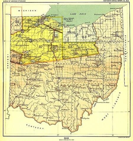
The Treaty of Fort Industry signed away the land from Native people and expanded lands for settlers. The land (shown in the map in yellow) became the ‘property’ of the United States government.
The grandson of an early settler described what is now Green Township as his grandfather recounted the story to him. ‘The Virgin forests were dense and beautiful, dark in aspect and deep beyond measure in magnitude. They were unbroken and interwoven with vines and underbrush. In many places, swamps, underbrush and high-ranking weeds covered the lowlands. Indians and wild animals roamed through the swamps and the dark avenues of the forest. Serpents and reptiles abounded in abundance over the land. The hawk, buzzard, and eagle proclaimed their dominion from the treetops. ‘ (History of Smithville by Paul G. Locher)
The historian Benjamin Douglass wrote specifically about Green Township in his 1878 History of Wayne County. ‘The early inhabitants of this township observed one peculiarity in the first occupancy of it. It was a wilderness, overgrown with timber, with the exception of about twelve acres on the south-west quarter of Section three, which was clear of trees, stumps, and even roots, and was called by the early settlers, ‘the Indian’s Field’. If a twelve-acre field was notable to be mentioned in a local history, it was because of its contrast to the old growth forest that surrounded it. Green Township was not originally a place of sunny grassy meadows.
Settlers initially saw the forests as a commodity to be harvested. Green Township is said to have had the heaviest and most plentiful timber of any township in the county. Historians noted red, white, and black oak, hickory, chestnut, walnut, maple, beech, ash and elm. Soon, the settlers saw the forests as an obstacle that needed to be overcome. They set about clearing the forests to make farms instead. David Stanley wrote in his personal memoirs:
‘The land was considered very thoroughly grubbed when the plough could run 10 feet without meeting a stump or root. The clearing of the land in those days embraced the girdling of the big timber, the grubbing out of all bushes less than 6 inches in diameter, and the cutting down and burning or removing of all saplings up to 10 inches…After the first clearing, the heavy deadened timber remained. Huge dead trees dotted over the fields, their bare bodies and naked limbs in the dusk of the evening, or the pale light of the moon having a most dismal and ghostlike appearance. The removal of this huge crop of dead trees was a giant task. Many of the trees 4 feet or more in diameter were chopped down. (and burned)… All consumed for no more purpose but to get rid of it. … It had to be removed to make way for the cornfield. Burning of the heaps was a week’s work.’
When the white settlers came, many acres of the Great Eastern Hardwood Forest were intentionally removed to make way for farming. The Great Eastern Hardwood Forest was said to be second only to the Amazon rainforest in terms of diversity of species. In the late 1700s, the forest cover in what is now the state of Ohio was estimated at 95 percent. Massive forest clearing for crop production dropped the forest cover to just 10% of the state by 1910. Today, about 30% of Ohio is forested.
The Arrival of Our People
Amish Mennonite settlers began moving to what is now Green Township from Somerset County, Pennsylvania to take advantage of this ‘available’ land to which they could now have a clear title. Land could be purchased directly from the United States government with land patents signed by the President of the United States.
I adapted Wendell Berry’s poem originally written about his home in Kentucky. My changes are in parentheses.
From (Pennsylvania) they came to wilderness old past knowing, to them new.
A quiet resided here, into which come these new ones,
minds full of purpose, loud, small, reductive, prone to disappointment.
They surveyed their places in it, established possession.
(‘From the Tuscarawas River and Cuyahoga River westward to a line 120 miles west of the Pennsylvania boundary.’)
Within that figment geography of random landmarks, the trees were felled. The plows scribed their lasting passages, exposing the ground to the sky.
The hot sun and hard rain then came down upon it, undeflected by a shadow or a leaf.
What was there that they so much wanted to change?
They wanted a farm, not a forest.
From then to now, no caring thought was given to these slopes ever tending lower.
Thus nature’s gift, her wealth and ours, is borne downstream, cluttering the bottom lands in passing,
and finally, is lost at sea.
As the Amish Mennonite and other settlers came to this land that would be called Green Township, they were surely aware of the presence of the native people who had so recently occupied the land before their arrival. They knew about the twelve-acre cleared field. John Winkler, an early settler in Green Township, remembered that there was an Indian Camp at Crouse’s farm between Paradise and Smithville. He remembered that they were peaceable and frequently returned to visit their old hunting grounds.
After the Treaty of Fort Industry in 1805, the United States government kept working to intentionally remove the indigenous inhabitants of Ohio. The Wyandot were the last to be removed from the state in 1843 through a series of treaties negotiated on behalf of white settlers. The Shawnee now live in Oklahoma. The Wyandot were removed to Kansas. Some Leni Lenape went to Canada.
The people were lost. The forests were lost. Some animals, like the formerly abundant passenger pigeons, were lost to extinction. Much soil was lost.
The Land Where We Live
John Stutzman, an Amish Mennonite from Somerset County, Pennsylvania arrived on the land where we live in 1814 at age 16. He claimed and purchased 320 acres of Section 10 of Green Township. He received a patent for the land from President James Monroe. According to the Treaty of Fort Industry, when the ownership of the land changed from the US government to John Stutzman, native people were no longer allowed to use the land for hunting.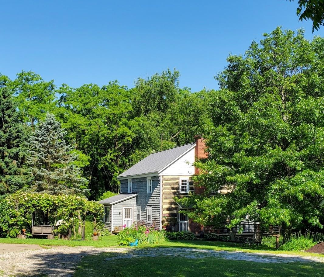
The 76 acres and the house where we now live was a part of the 320+ acres owned by John and Sarah Stutzman. With all those acres to choose from, John and Sarah Stutzman chose this particular spot for a house, at a time when there were only three other houses anywhere in Section 10. It is beautifully situated among rolling hills and between two springs.
John and Sarah Stutzman were some of the original members of the Oak Grove Amish Mennonite Church. Because the church did yet have a cemetery, it makes sense that family members who died before 1854 are buried on the farm. There may also be native gravesites.
John and Sarah Stutzman had 13 children over a period of 22 years. The deaths we are aware of include:
1829: Infant boy (age 2)
1833: John Stutzman (age 2) 1834: Freeman Stutzman (infant) 1844: Christina Stutzman (age 1)
1845: Anna Stutzman (age 15)
1854: Lydia (Harmon) Stutzman (age 24 of typhoid)
1854: John Stutzman (age 52 in the same typhoid epidemic)
We assume that all these people are buried on the land. A registered cemetery in the northeast corner of the land has just one remaining marker for Lydia (Harmon) Stutzman, wife of David B. Stutzman and daughter-in-law to John and Sarah. She died in a typhoid epidemic on August 15, 1854, aged 22 years, 10 months, and three days.
Sarah (Blough) Stutzman, John’s widow, died much later at the age of 78. She was buried in 1880 in at Oak Grove Mennonite Church, which had a cemetery by that time.
A Stutzman descendent sold this land to William Crites sometime before 1908. My grandparents, Aldine and Velma (Steiner) Zimmerly bought the eighty-acre farm from Emanuel Crites in 1932. My grandma’s family were Amish Mennonite settlers and my grandpa’s family were Swiss Mennonite settlers who both came from settler farms within two miles of this land. With generational connections to this land, the Stutzman family, the Crites family, and the Zimmerly family are the only families to have lived on the land since 1814.
My grandparents loved this land and struggled to keep it during difficult times, especially during my Grandma’s serious illness. My Grandpa Aldine sold the farm to my Grandma, Velma, in 1950 for $1. In 1960, my dad, Glenn, wrote home from Indonesia (where they were serving with MCC) ‘If you are having difficulties with the money end of it, Martha and I can at least help with several hundred dollars. Just write and tell us and we can have it sent from the bank at Wooster. Oh yes, don’t sell the farm!’
Aldine and Velma took out a mortgage on the farm in 1963. My grandparents sold the farm to my parents, Glenn and Martha, in 1966 for $1. Glenn and Martha took out another mortgage in 1966. Both my grandpa and my dad worked in other jobs to be able to keep the land. My parents eventually expanded their acreage by purchasing the farm of my great grandparents, Jacob and Anna Zimmerly and another acreage both in Section 14 of Green Township.
The farm was finally paid off with an inheritance from my maternal grandfather in the late 1990s. In 1998, my parents gathered their two children and their families to discuss the future of the land.
They wanted to do an agricultural easement or to donate the land for mission. They eventually decided to keep the land to allow my brother’s family and our family to continue to serve and volunteer in ways that would not guarantee a retirement income.
After the death of my mother in 2002 and my dad in 2006, my brother’s family and our family inherited the land. We sold off the other two farms so that my brother could purchase a farm in Ontario. We eventually returned to the home farm in 2017.
Donating a Conservation Easement
Our family has deeply loved and cared for this land for generations. In some ways, we depend on the land as our retirement plan. Yet the land is stolen land. Because of our experiences, we no longer think of the land as a commodity or refer to it as a ‘property.’ The land is the land. We live on it and have a responsibility for it.
Joy Harjo, the 23rd Poet Laureate of the United States, a member of the Mvskoke (Muscogee Creek) Nation, writes
Bless us, these lands, said the rememberer.
These lands aren’t our lands. These lands aren’t your lands.
We are this land.
Tarhe the Crane, a Wyandot chief, eventually signed the Greenville Treaty in 1795. Still, he believed that no one owned the land and no one had the right to sell it out from under anyone. Tarhe explained his understanding of the land to Anthony Wayne, the military general who had ‘won’ the land.
‘It belongs in common to us all. No earthly being has an exclusive right to it. The Great Spirit above is the only true and right owner of the soil; and he has given us an equal right to it.’ (Mary Stockwell, The Other Trail of Tears: The Removal of Ohio Indians; Westholme, 2016)
This echoes our own Anabaptist faith tradition. David the psalmist declares in Psalm 24: ‘The earth is the Lord’s and everything in it, the world and its inhabitants too.’
Our son, Ben, proclaimed this when we visited Ohio from Congo on a home leave when he was three. We had been living in a village in what is now DR Congo on traditional lands, held communally. In Ohio, Ben asked to walk across my uncle’s fields to a woods that he could see in the distance. When we explained that he didn’t have permission because those woods belonged to someone else, he became indignant and confused. ‘How can those woods belong to someone? They belong to God!’
Author Wendell Berry reflects the settler paradigm of property/title, but still sees the land as a gift and our responsibility to be the land’s caretakers. He writes,
‘The ecological teaching of the Bible is simply inescapable. God made the world because He wanted it made. He thinks the world is good and He loves it. It is His world. He has never relinquished title to it. And He has never revoked the conditions bearing on his gift to us of the use of it, that oblige us to take excellent care of it.’
Over the years, my parents, Glenn and Martha Zimmerly, cared for the land in the best way they knew as an expression of their faith. We inherited my dad’s copy of the book, Earthkeepers by his friends, Art and Jocele Meyer, with chapter titles of ‘New Testament Environmental Ethic’ and ‘Ecojustice: a Theology of Ecology.’ My dad taught vocational agriculture and was an early adopter of conservation practices including contour farming, no-till planting, grass waterways, afforestation of a ravine and a wildlife pond built with government conservation assistance.
<